North Dakota Lakes GPS Charts 4.4.4.4
Paid Version
Publisher Description
North Dakota Lakes GPS Charts - Marine and Fishing Charts - The power of a GPS plotter in the palm of your hand
Flytomap is a valid and interesting alternative
Featured on the Deck
Featured on Geomedia
Worldwide Marine & Outdoor Maps available when connected, thanks to viewer.flytomap.com
Worldwide Satellite images overlay on charts
Worldwide Terrain features overlay on charts, thanks to Open Street Map, Open Cycle Map,Earth,topo maps by ESRI
Now with NOAA raster charts seamless with continuous updates from the official Government server
Use to Explore
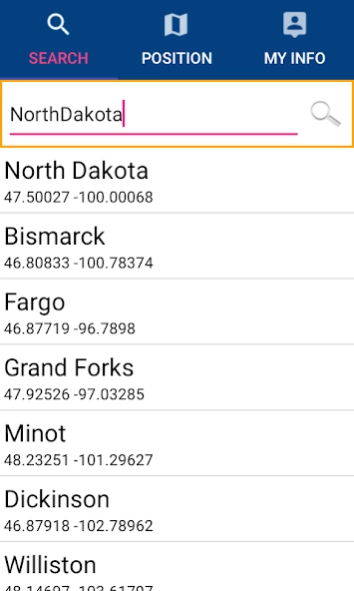
√ Latitudes & Longitudes to go to your favorite places
√ Search your Favorite points directly
√ Zoom, Rotate & Pan fast just by a finger touch
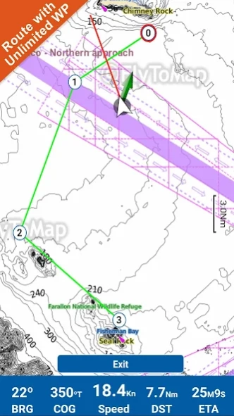
√ Route with unlimited waypoints
√ With Head Up & Course Up feature
√ Geocompass
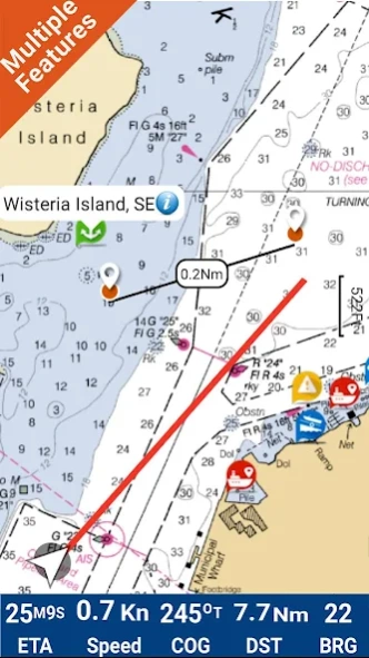
√ Navigate & see your GPS position on the map
√ Heading Vector Towards the direction movement
√ Distance Measurement Tool to easily calculate the distance from one location to another
√ Insert the destination & see in real time your speed, distance & bearing
√ background mode - Flytomap works in background as well, you can swap with another app & receive/make calls send sms while panning & zooming
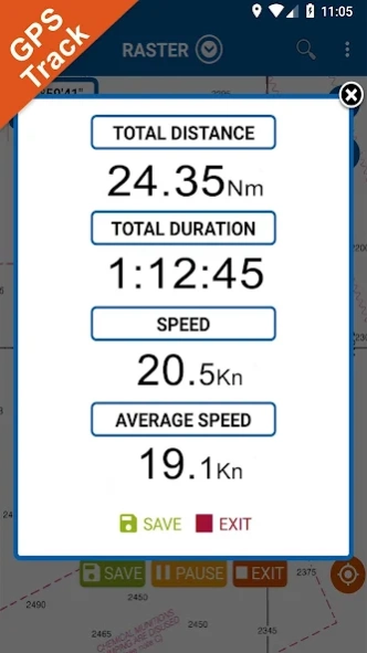
√ Unlimited Tracks share via email, visible on Google, Flytomap Viewer, KMZ format Store your track without the need of cellular data / mobile signal
√ KMZ KML from to GPX Converter
√ And so much more to come It’s the only app you will ever need! Our charts are installed on: NAVICO LOWRANCE B&G NORTHSTAR EAGLE SIMRAD
Follow us
▶Twitter @flytomap
▶Web Site flytomap.com
▶Web App viewer.flytomap.com
▶Facebook facebook.com/flytomap
The entire cartography of North Dakota Lakes is included in this application
ELSIE
HORSESHOE
LUECK
WAHL
TEWAUKON
ALKALI
SPRAGUE
SILVER
KANDIOTTA
KRAFT SLOUGH
DEAD COLT CREEK
LAMOURE
TWIN
PHEASANT
COLDWATER
CLEAR
GREEN
GOOSE
HOSKINS
BEAVER
NEUWSMA
RICE
BRADDOCK DAM
ALKALINE
ISABEL
SUBLEY
CHERRY
LAKE WILLIAMS
ROUND
BARNES
PIPESTEM
JAMESTOWN RESERVOIR
SPIRITWOOD
LAKE ASHTABULA
MOON
SAINT MARYS
BREWER
GOLDEN
NORTH GOLDEN
SIBLEY
DRY
JUANITA
ADDIE
RED WILLOW
LAKE COE
BATTLE
JAMES RIVER
SILVER CREEK
STUMP
LARETTA
SOUTH BRANCH TURTLE RIVER
HOMME RESERVOIR
RENWICK
WOOD
CAVANAUGH
ARMOURDALE
GRAVEL
LAKE UPSILON
HOOKER
DION
SCHOOL SECTION
CARPENTER
SCHUTTE
SAND
DAVIS
BUFFALO
GOOSE_2
LAUINGER
ROUND_2
ANTELOPE
CLEAR(PIERCE)
COAL MINE
HIAWATHA
JOSEPHINE
HELEN
WOODHOUSE
HECKERS
NELSON
HARMON
CROWN BUTTE
SWEET BRIAR
FISH CREEK
STORM CREEK
TSCHIDA
NORTH LEMMON
MIRROR
BOWMAN-HALEY
SPRING
CEDAR
LARSON
EDWARD ARTHUR PATTERSON
CAMELS HUMP
CHICKEN CREEK
SATHER
ARNEGARD DAM
TRENTON
BLACKTAIL
EPPING DAM
MCLEOD
TIOGA DAM
WHITE EARTH RIVER
POWERS
SMISHEK
COTTONWOOD_1
SKJERMO
EAST BRANCH SHORT CREEK
LONG_1
PELICAN_1
STRAWBERRY_1
METIGOSHE
BUFFALO LODGE
COTTONWOOD_2
STRAWBERRY_2
LONG_2
CROOKED
NELSON AND CARLSONS
RICE_2
HIDDENWOOD
DARLING
DEVILS
PELICAN_2
BRUSH
HOLMES
BREKKEN
LLO
MOORES
FROELICH
MAKOTI
MOORETON
CONSOLIDATED
LIMESAND-SEEFELDT
HEINRICH-MARTIN
KULM-EDGELEY
SCHLECHT-THOM
FLOOD
DIAMOND
SCHLECHT-WEIXEL
KALMBACH
SCHLENKER
WILSON
BLUMHARDT
LEHR WMA
MUNDT
DORFMAN
RUDOLPH
MARVIN MILLER
CLARK
BIG MALLARD MARSH
CRYSTAL SPRINGS
BADER
HEHN-SCHAFFER
WILDLIFE SANTUARY
CLAUSEN SPRINGS
WARSING
TOLNA
McVILLE
WHITMAN LOWER
WHITMAN UPPER
MATEJCEK
FORDVILLE
BYLIN
LANGDON CITY
MOUNT CARMEL
BISEE DAM-BIG COULEE
JENSEN
BALTA DAM_1
BALTA DAM_2
HARVEY
HURDSFIELD-TUFFY
FRETTIM
REMMICK
SCHUMACHER
JASPER
DAVIS WPA
S. (HOFFER) McCLUSKY
COTTONWOOD PARK
McDOWELL
WEST ARRODA
EAST ARRODA
NYGREN
SHEEP CREEK
RALEIGH
DAVIS DAM
INDIAN CREEK
CASTLE ROCK
BLICKENSDERFER
MOTT WATERSHED
DICKINSON DIKE
BELFIELD
BUFFALO GAP
ODLAND DAM
EAST SPRING
WEST SPRING
KOTA-RAY
OLSON (WILLY)
IVERSON
MCGREGOR
STANLEY
EAST MINE
BAUKOL-NOONAN
SPILLWAY
TANBERG
NORTHGATE
NELSON LANDERS
CARBURY
NORTH CARLSON
LIGHTNING
HARMONY
RIVER DALE SPILLWAY
CUSTER MINE
EAST DEVILS
GDU CANAL(NEW JHONS)
GDU CANAL(E.PARK)
WEST PARK
About North Dakota Lakes GPS Charts
North Dakota Lakes GPS Charts is a paid app for Android published in the Geography list of apps, part of Education.
The company that develops North Dakota Lakes GPS Charts is FLYTOMAP INC. The latest version released by its developer is 4.4.4.4.
To install North Dakota Lakes GPS Charts on your Android device, just click the green Continue To App button above to start the installation process. The app is listed on our website since 2022-10-21 and was downloaded 2 times. We have already checked if the download link is safe, however for your own protection we recommend that you scan the downloaded app with your antivirus. Your antivirus may detect the North Dakota Lakes GPS Charts as malware as malware if the download link to com.flytomap.marineapp.worldviewer.lakenorthdakota is broken.
How to install North Dakota Lakes GPS Charts on your Android device:
- Click on the Continue To App button on our website. This will redirect you to Google Play.
- Once the North Dakota Lakes GPS Charts is shown in the Google Play listing of your Android device, you can start its download and installation. Tap on the Install button located below the search bar and to the right of the app icon.
- A pop-up window with the permissions required by North Dakota Lakes GPS Charts will be shown. Click on Accept to continue the process.
- North Dakota Lakes GPS Charts will be downloaded onto your device, displaying a progress. Once the download completes, the installation will start and you'll get a notification after the installation is finished.
